The Ho Chi Minh Trail: Hiking La Jolla’s Sandstone Slot to Black’s Beach
Surfer Lore: Carving a Path in the 1960s
To understand how this precarious footpath came to exist, you have to rewind to the surf culture of late-1960s San Diego. Just below the 300-foot coastal bluffs of Torrey Pines lies Black’s Beach, home to one of the most powerful deep-water ocean swells on the West Coast. The Scripps Submarine Canyon funnels incoming northwest winter swells directly into the shoreline, creating steep, hollow, A-frame waves that break with thumping force.
In those days, reaching Black’s Beach required either a punishing two-mile trek down the beach from Torrey Pines State Beach at low tide, or navigating the steep dirt road controlled by local landowners.
Students and surfers from the newly founded University of California San Diego (UCSD) campus began scouting alternative routes down the canyon ravines. Armed with surfboards under their arms, they cut an informal trail through the chaparral, tracing natural water drainage channels that winter rains had gouged through the soft sedimentary cliffs.
Because navigating the narrow trenches, bamboo reeds, and hidden drop-offs felt like a tactical jungle route during the height of the Vietnam War era, local surfers christened the shortcut the "Ho Chi Minh Trail." Over the ensuing five decades, hundreds of thousands of surfers and adventurous hikers have filed through the same sandstone chute, wearing the soft rock into smooth, parabolic troughs.
The Geology: Eocene Sandstone and Flash Runoff
The striking terrain of the trail is a direct product of San Diego's coastal geology. The bluffs here consist of two primary rock layers: the 45-million-year-old Torrey Sandstone and the underlying Delmar Formation.
Torrey Sandstone is a porous, medium-to-coarse-grained rock formed from ancient sandbars deposited in a shallow subtropical bay during the Eocene epoch. Because it is poorly cemented, it is exceptionally vulnerable to water erosion. Over thousands of years, winter storm runoff flowing down from the mesa eroded vertical joints in the rock, carving fluted slot canyons with swirling, multi-colored bands of gold, rust, and cream.
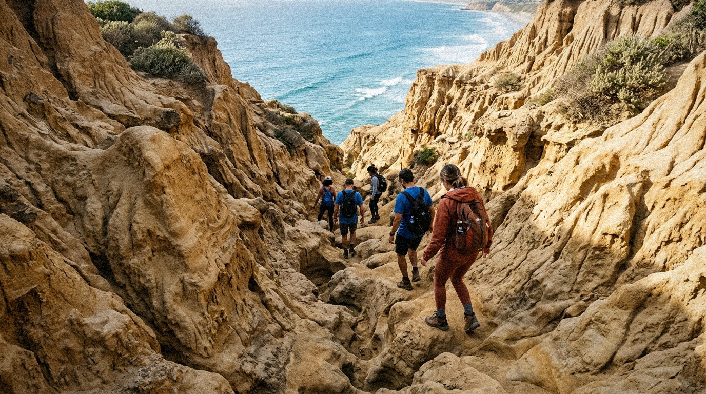
As you descend, the trail narrows into a tight sandstone trench. In several sections, the canyon walls rise ten to fifteen feet above your head, barely shoulder-width across. Decades of footsteps have polished the floor into slick, concave chutes where hikers often slide on their rear ends or stem their hands against opposing canyon walls for balance.
Never attempt this trail in flip-flops or smooth-soled street shoes. The polished sandstone is covered in a fine layer of loose sand grains that acts like ball bearings underfoot. Wear athletic shoes or hiking boots with aggressive rubber tread. If it has rained within the past 48 hours, stay off the trail entirely: the wet sandstone turns into slick clay, erosion accelerates, and coastal bluffs become prone to sudden collapse.
Navigating the Trail Obstacles
Covering roughly 0.7 miles each way with an elevation change of about 300 feet, the hike is short but physically demanding. The route presents three distinct technical obstacles:
1. The Sandstone Trenches
The upper half of the trail winds through coastal sage scrub before dropping into the sandstone slots. The trench walls feature natural handholds scooped out by centuries of rainwater, but the footing is uneven. Move deliberately, keep your center of gravity low, and avoid rushing through the steep concave drops.
2. The Wooden Plank Crossing
Near the midpoint of the canyon, water erosion washed out a section of the path, creating an eight-foot crevasse with a sheer vertical drop. Decades ago, local trail users wedged a thick wooden plank across the gap to maintain passage. Crossing requires a steady foot and careful balance. Take one deliberate step at a time, keeping your eyes on the board rather than the ravine below.
3. The Fixed Rope Descent
The crux of the route arrives near the base of the canyon. To reach the beach sand, you must negotiate a 25-foot slope of near-vertical, crumbly sandstone. Good Samaritans and local surfers maintain a thick knotted climbing rope anchored to metal posts at the top of the chute.
Descend facing the rock face, using the rope as a brake while walking your feet backward down the slope one notch at a time. Do not put 100% of your faith in the rope; always inspect the anchor point and test the knot before committing your full weight.
Arriving at Black’s Beach
Emerging from the mouth of the canyon onto the wide sand of Black’s Beach feels like stepping into a hidden amphitheater. Towering 300-foot bluffs rise vertically behind you, shielding the shoreline from inland city noise. Overhead, hang gliders and paragliders launched from the Torrey Pines Gliderport ride thermals along the cliff edge like giant mechanical birds.
Visitors should be aware that the two-mile strip of sand stretching north from the trail exit is unofficially recognized as California's largest clothing-optional beach. While nudity is officially banned by city municipal ordinance south of the boundary line, the tradition has persisted at Black's Beach for over fifty years. The atmosphere is generally relaxed, quiet, and dominated by serious surfers, sunbathers, and coastal walkers.
Essential Safety Logistics
- Check Tide Tables: High tides can push ocean waves right against the base of the cliffs, cutting off beach exits. Always time your hike during a falling or minus tide so you have ample beach clearance.
- Keep Off the Bluff Base: Torrey Pines sea cliffs are geologically active and experience periodic rockfalls. Avoid sitting or sunbathing within 25 feet of the vertical cliff face.
- Return Route Options: If climbing back up the steep rope chute and slippery plank feels daunting, you don't have to retrace your steps. You can walk north along the beach for 1.5 miles to the Torrey Pines State Beach parking lot, or walk south past Scripps Pier to La Jolla Shores at low tide.
- Trailhead Parking: Street parking along La Jolla Farms Road is extremely limited and subject to strict parking restrictions. Read posted signs carefully to avoid citations. Alternatively, park at the Torrey Pines Gliderport lot and walk down La Jolla Farms Road to the trailhead.


Comments
Post a Comment